The Harappan Civilization (Settlement Pattern)

The Harappan Civilization (Settlement Pattern)
Last Updated On: 14 August 2023
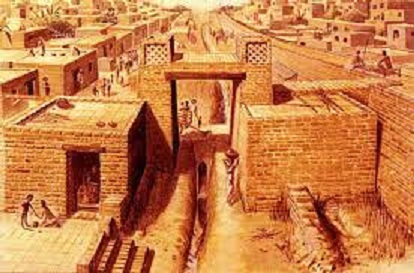
The settlement pattern was a multi-tiered one with urban and rural sites that were markedly varied in terms of size and function. There were cities of monumental dimentions like Mohenjodaro, Dholavira and Rakhigarhi that stand out on account of their size and the character of their excavated remains. While the older premise that such cities were based on a gridiron system of planning has been shown by recent reserch to be invalid, there is impressive evidence of centralized planning. City space was divided into public and residential sectors. At Harappa and Mohanjodaro the seperation of the largely public administrative sector from the residential part of the city took the form of two separate mounds. Dholavira's city plan was more intricate. At its fully developed stage, it had three parts made up of the citadel which was divided into a castle and a bailey area the idle town and the lower town all interlinked and with in an elaborate system of fortifiction.
The character of some of the structure is also worth considering. Mohenjodaro citadel for instance was constructed on a gigantic artificial plateform made of a mud brick retaining wall enclosing a filling of sand and slit. This plateform after being enlarged twice, attained a final height of 7 meters and provided a foundation on which further plateforms were built in order to elevate important structures such as the Great Bath and the granary, so that the highest building were about 20 meters above the surrounding plains and could be seen on the horizons for miles around. Another architectural marvel is Dholavira's system of water management, crucial in an area, which is prone to frequent droughts. Rain water in the catchment areas of the two seasonal streams - Manhar and Mansar was dammed and diverted to the large reservoirs with in the city walls. Apparently there were 16 water reservoirs within the city walls, covering as much as 36 percent of the walled area. Bricks masonry walls protected them, although reservoirs were also made by cutting into the bedrock. Furthermore, drains in the castle-bailey area carried rain water to a receptacle for later use.
The intermediate tier of the urban hierarchy was made up of sites that in several features recall the layout of the monumental cities of the civilization but are smaller in size. Kalibangan Lothal, Kot Diji, Banawali and Amri are some of them and they can be considered as provincial centres. Kalibangan like Mohenjodaro and Harappa, comprised of two fortified mounds - the smaller western one contained several mud brick plateforms a similar type. Lothal war also a fortified town with its entire eastern mound had fire altars of a similar type. Lothal was also a fortified town with its entire eastern sector being taken up by a dockyard which was connected with entire eastern sector being taken up by a dockyard which was connect with the river through an intel channel. In its vicinity was the acropolis where the remains of a storehouse, in which clay sealing, some with impressions of cords and other materials on them, were discovered. Lothal's urban morphology also suggests that there is no necessary relationship between the size of a city and its overall planning. Mohenjodaro was at least 25 times the size of lothal but the latter shares with it the presence of two seperate areas, burnt brick houses and regularly aligned streets and drains. In fact it paved streets and lanes are unrivalled in the Indus context. The third tier of the Indus settlement hierarchy is made up of small, urban sites these show some evidence of planning but no enternal sub division. Not with standing their size and structurally unprepossessing character, they had urban function. Allahadino in Sind is one such site, which had a diameter of only 100 metres but was an important metal crafting centre. Similarly Kuntasi in Gujarat is a small Harappan fortified settlement where semi precious stones and copper were processed.
Finally urban centre were supported by and functionally connect with rural hinterlands of sedentary villages and temporary settlements. While the latter are generally small with thin occupational deposits in the case of villages, outlines of huts and relatively thick deposits have been encountered. Kanewal in gujarat for instance, is 300 square meters and its cultural deposit is suggestive of secure village settlement. Similarly the archaeological deposits of the Harappan phase in the Yamuna Ganga doab 1.8 meters at Alamgirpur and 1.4 metres at Hulas indicates that the pioneer colonizers of that area lived there for a long period of time. What is worth remembering is that on the basis of size, it is not wise to distinguish rural and urban sites of the Indus civilization. In Cholistan there are a few large sites, one of which cover 25 hectares which have been described as nomadic settlements, not urban ones. On the other hand Kuntasi was only 2 hectares in size but has been rightly classified as an urban settlement because of its functional role as a provider of craft objects.